Colorado RV Camping – Silverton
These Colorado RV camping maps are provided to assist you in finding RV camping locations near Silverton. Locations displayed are approximate, and are offered only as a guide and should not be used for navigation. Public lands are administered by USA and state government departments, and you should consult with the local public land management office for specific RV camping and access information if you are unsure of local policies.
To find free RV camping sites near Silverton, you need good maps. We recommend the Colorado Road and Recreation Atlas (Benchmark) as a great paper recreation resource.
Silverton Colorado Location
This is the Location of Silverton, Colorado. RV camping is permitted on BLM (Bureau of Land Management) and USDA Forest Service (USFS) managed lands in the Silverton area. Silverton is located in the San Juan Mountains of Colorado, often referred to as the Switzerland of America, and is a popular vacation destination. The Durango & Silverton Scenic Railroad is a popular tourist attraction in this area, and the mining history is very visible throughout this area. Silverton has groceries, fuel, water, RV supplies, and numerous tourist oriented businesses.

Free Colorado RV Camping Locations
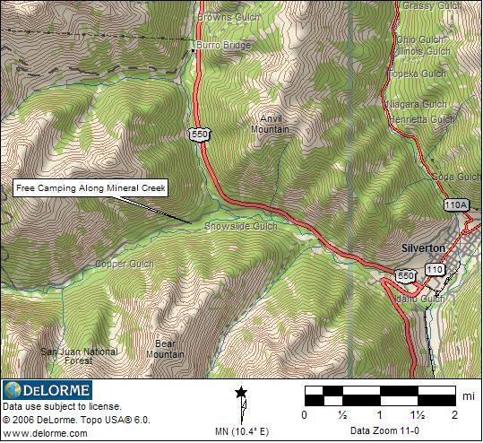
Free RV camping is allowed at numerous locations near Silverton. The following maps show one free and one low cost location that are especially useful to Recreational Vehicle campers. The Mineral Creek campground area has vault toilets, but no other facilities. Both locations are suitable for any size RV. The first map shows the Mineral Creek camping area.
The following map shows the Eureka town site camping location. As of 2012, the Eureka townsite dispersed camping area is managed by the town of Silverton and there is a $10 per night charge. We’ve decided to leave the RV camping location information as this is a beautiful camping area available for at a low price.

BLM & USDA Forest Service Managed Lands
Free RV dispersed camping (boondocking) is permitted extensively on Public Lands around the Silverton area. BLM (Bureau of Land Management) and USFS (USDA Forest Service) manage lands in the area, and both allow dispersed camping. Our Colorado Web Page, has links to the USFS and BLM sites that administer lands in this area. The purple shaded areas on the following map show BLM administered lands, and the light green shaded areas are USFS managed areas.

The location map images for finding RV camping locations near Silverton Colorado are derived from DeLorme Topo 6.0 Software and used with their exclusive permission.
Return to Colorado RV Camping